
Mountain Flight (KTM - KTM) 1hr
Kathmandu - Lukla - Kathmandu
Kathmandu - Pokhara - Kathmandu
Pokhara - Jomsom - Pokhara
Kathmandu - Bharatpur - Kathmandu
Complete Travel Solutions
24 Hours Support Call
+977-9841570317 (Shankar Pandey)
email:info@adventurehikenepal.com
24 Hours Support Call
+977-9841570317 (Shankar Pandey)
email:info@adventurehikenepal.com

New Trekking Routes
Remote Trekking Routes
Family Trekking Routes
Car Rental In Nepal

Annapurna Circuit Trekking
| Annapurna Base Camp Trek Annapurna Luxury Trek Khair Lake Trek Annapurna Circuit Trek Ghorepani Trek Jomsom Muktinath Trek Dhaulagiri Trek Narphu Valley Trek Siklish Trek Tilicho Lake Trek |
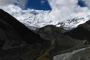 Annapurna Circuit Trekking offers great variety of sub-tropical plains in the Himalaya... foothills through the trans-Himalayan Manang and Mustang regions. The trek goes through Thorang-La Pass-5416m. Between two valleys of Manang and Kaligandaki River gorge (the deepest gorge of the world). Above combinations make this trek one of the most famous in Nepal. It shows diverse culture, nature and traditional values.
Annapurna Circuit trek is one of the classic and most rewarding treks in the Himalayas. It provides an opportunity to explore the scenery of both the southern and northern Himalayas. You can encounter rhododendron forests, the thin Tibetan Highland atmosphere as well as many ethnic groups on the way.Trekking north, we acclimatize at the important trading village of Manang (3351 m.) before crossing the Thorong-La (5407 m.).When you reach the pass, line after line of snow ridges stretch before you while far below lies the sub-tropical Kali Gandaki Gorge.From the heights of the Pass we descend to Muktinath and its sacred Buddhist and Hindus shrines. Further south, the contrast of the Nepal Himalaya becomes even more apparent as forests or mandarin and banana groves replace high windswept passes.Finally we trek out of the gorges and look back to the peaks of the Annapurna and Dhaulagiri before traversing the forest ridges down to Pokhara.
Day to day itinerary for Annapurna Circuit Trek
Day 01: Arrival day in Kathmandu (1,300m/4,264 ft)
Welcome to Himalayan country of Nepal. Upon your arrival at the Tribhuvan intl. airport our representative welcomes you and assists to transfer in your hotel in Kathmandu. After time to get refreshed, evening you'll meet and transfer for welcome dinner in one of the typical Nepalese restaurant in the heart of Kathmandu and briefing about your trip and overnight at Hotel.
Day 02: Kathmandu valley sightseeing & trek preparation (1,300m/4,264 ft)
After breakfast the day will start to our guided trip to cultural world heritage sites in Kathmandu valley; the pilgrimage sites of Hindus temple Pashupatinath, the world biggest Bouddhanath Stupa and visit Swoyambhunath Stupa also known as monkey temple. After exploring the surrounding areas visit historical Kathmandu Durbar Square with temple, unique architectures and Kumari (living goddess). Evening pre-trip discussion and introduce with our fellow trekking staff for your adventure trip.
Day 03: Drive to Beshishahar (830m/2,723ft), 6-7 hrs drive
This morning we leave Kathmandu for our long trek to Annapurna. Drive by local bus to Beshishahar through the beautiful Nepalese countryside. Beshishahar is big town and district headquarters of the Lamjung District, explore the surrounding area and overnight at the hotel.
Day 04: Trek to Bahundanda (1,310m/4,298ft), 5-6 hrs walk
Today, we begin our trek from Beshishahar with fine view of Hiunchuli and peak 29 (Ngadi Chuli) and crossing some local wooden & bamboo bridges reaches at Bhulbhule. It then continues to Ngadi village for lunch passing through waterfall through the river bank before reaching at Bahundanda for overnight. This is nice village on a top of hill and you may have chance to explore the evening time to local village and around the school areas.
Day 05: Trek to Chamje (1,410m/4,626ft), 5-6 hrs walk
After a breakfast the trek descends to Syange village crossing fields and local villages, a short downhill walk brings you Syange village is reached after crossing a long suspension bridge, and our trek continues gradually uphill from the river and the last steep climb to get to Jagat for lunch stop. From here an hour further walk on rocky path & long scenic waterfall across the river and finally brings you at Chamje for overnight stop.
Day 06: Trek to Dharapani (1,960m/6,430ft), 5-6 hrs walk
From Chamje a short walk brings to a suspension bridge over the raging Marshyangdi river, after crossing the bridge it's another steep climb for another 2-3 hours till Tal, the village is situated on the gorge-valley by the side of the river Marshyangdi and decorated with beautiful waterfall & sandy spread river. Further trek follows the upstream up to the Dharapani, which is through the rocky trails and crossing few suspension bridges and small teashops bring you at quite large village at Dharapani for the overnight at hotel.
Day 07:Trek to Chame (2,710m/8,891ft), 6-7 hrs walk
We continue our trek further to Chame. From where changing the vegetation, people and the landscapes changes and the air will gets cooler, the trail then climb through pine forests to Bagarchhap, the first village on the trek with typical Tibetan architecture. After a pleasant walk to Bagarchhap, the altitude slowly gains as we come at Danaque and to the alpine region passing through farm, orchards and beautiful pine forest with views of towering peaks of Lamjung and Annapurna II, the trail follows the river Marshyangdi upstream passing by the villages of Latamanang and Koto before further half an hour brings you at Chame for overnight at the hotel. This is head quarter of Manang district with grand view of Annapurna II.
Day 08: Trek to Pisang (3,200m/10,496ft), 5-6 hrs walk
The trails leads from the other side of the river on the northern bank passes through pine woods and small villages with few ups and downs till you reach the orchard village of Bhartang for apple garden. We continue on the gradual path up to a bridge, from the bridge a short steep climb through the pine forest brings you at the top of the ridge of Dhukur Pokhari for the lunch. After walking out of the tree line a great view of Pisang peak on the north and the Chulu peak can be seen with Pisang village below you, from this top a gentle descent of one hour brings you to windswept village of Pisang for overnight. Evening visit upper Pisang for the Tibetan style of houses and monastery with panoramic view of the Annapurna range and valley.
Day 09: Trek to Manang (3,500m/11,482ft), 4-5 hrs walk
The trek starts with pleasant walk through pine forest and the scenic view. The walk climbs gently up for half an hour and reaching the top, stop at a ridge to get our first view of the Manang valley, This grand spot offers a spectacular views of the valleys, Humde village with it's short air-strip and the great peaks of Gangapurna, Annapurna II & III, Tilicho and on the right Chulu east, on the back Pisang peak. The walk forward to Humde and pleasant walk up to the Braga village for traditionally built up Tibetans style of houses and if can be visited the monastery, it has an outstanding display of statues, Thanka paintings and the religious manuscripts. From here it is only an hour walk to Manang for the overnight.
Day 10: Acclimatization day at Manang (3,500m/11,482ft)
Today is full of rest for acclimatize and explore Manang. The village of about 500 flat-roofed houses is the picturesque set amongst some spectacular scenery -Annapurna II, Annapurna III (7,555 meters), Gangapurna (7,454 meters) to the South - Tilicho (7,132 meters) and the Grand Barrier to the West - Chulu West (6,583 meters) and Chulu East (6,059 meters) to the North. After explore and relaxing day at Manang, visit Himalayan Rescue Association and if needed go for movie show.
Day 11: Trek to Yak Kharka (4,110m/13,484ft), 3-4 hours walk
After a wonderful time at Manang, the trail leads to a slow climb up for an hour to the Tenki Manang for enclose view of the Annapurna, Gangapurna and Tilicho peak. The track gently winds up offering inspiring views and through terrains with juniper bushes as the only surviving vegetation around this region and will brings you at Yak-Kharka for the overnight.
Day 12:Trek to Throng Phedi (4,400m/14,432), 3-4 hrs walk
We start our trek with slow and own pace to get to Phedi. We still have same amazing view of mountains and landscapes. After an hour walk reaches at Ledar and continues to climb along the east bank of the Jorsang Khola, then descends and crosses the stream on a wooden bridge to get a small tea shop. We stop for wonderful view and tea breaks, we follows a narrow path across a high, unstable slope before heading to Thorong Phedi for the overnight. Phedi, which means 'foot of the hill', is a common Nepali name for any settlement at the bottom of a long climb.
Day 13: Trek to to Muktinath (3,800/12,467ft) via Throng La (5,416m/17,765 ft), 7-8 hrs walk
Today is longest and hardest day of the whole trip. We start our walk early in the morning with packed lunch and the trail becomes steepest initially and reaches at high camp. Walk on your own pace viewing with sunrise and glimpse of the mountains. We continuing walk to the top takes 3-4 hrs to the Throng top and with a great feeling of victory take a short breaks for picturesque scenery and down to the Mustang part of mountains and the Kaligandaki valley far below to the West. Finally, we made to Muktinath after 7-8 hrs long walk and overnight at lodge.
Day 14: Trek to Marpha (2,670m/8,760ft), 6-7 hrs walk.
We visit temple in the morning and continuing our journey descending to the Kaligandaki river valley floor, with a brief stop at Ekle bhatti meaning a lonely teahouse, from here onwards the valley gets very windy path, the walk follows the gentle trail for another two hours till the large town of Jomsom a town and a headquarter of the Mustang region with a small airstrip just above the Kaligandaki River. After lunch at Jomsom further two hours of easy walk towards south east brings us at Marpha for the overnight stop, which is little gem, with whitewashed houses, paved streets and numerous well kept lodges. Here you will have time to celebrate with the local apple products like cider, brandy and juice and dinner with apple pie.
Day 15: Trek to Ghasa (2,120m/6,955ft), 6-7 hrs walk
Today, the walk is very enjoyable following the Kaligandaki river down stream reaches another charming village at Tukuche, close beneath the Tukuche peak and Dhaulagiri with spectacular views of Mt. Nilgiri's and the massif icefalls which tumbles from the Dhaualgiri's east face, after an hour walk from Tukuche continuing trek down to Kalolpani village for lunch, and this is another lovely village of more than 30 houses with excellent tea houses and lodge with grandeur view of Mt. Annapurna I, Nilgiri and Dhaulagiri above the beautiful pine forest. After 2 hrs easy downhill brings you long settled Thakali village for overnight at lodge.
Day 16:Trek to Tatopani (1,200m/3937ft), 4-5 hrs walk
The route dramatically changes the vegetation, from dry, arid desert to pine and conifer forests, as we pass between two giant peaks of Dhaulagiri and the Annapurna's. From Ghasa the southern end of the area dominated by Thakali people till Tatopani, the architectural style change, with much ornately carved wood work in evidence. This pleasant walk amidst the beautiful surrounding continues back to the terraced paddy fields and into warm sub-tropical climate all the way to the village of Tatopani passing through the beautiful waterfalls of Rupse waterfall. We come down through Dana village (the deepest gorge of the world) and after lunch onwards couple of hour to get to Tatopani for natural hot spring bath. Explore the local place and overnight at hotel.
Day 17: Trek to Ghorepani (2,850m/9,350ft), 5-6 hrs walk
After spending wonderful day at hot spring we trek down before crossing a suspension bridge over the Kaligandaki river, the path leads by the river for a while just arriving at the junction of the two trails, the other wide path follows the river all the way to Beni. We diverts from here taking the left uphill climb, the first of the climb is quite steep to the top, and continue with farms and villages, from this spot a gradual climb leads us most of the day, leaving behind the terraced fields walking in the dense rhododendron forests and reaching at Ghorepani for the overnight at teahouse. This is a great place for mountain scenery.
Day 18: Poon hill hike and trek to Tadapani (2,710m/8,891ft), 5-6 hrs walk
An early morning start for 40 minutes hike up to Poon hill (3210m/10530ft), the route offers the glimpse of the pleasant rhododendron forest. This brilliant viewpoint provides us an unobstructed sunrise over the high Himalayas and the wide range of panoramic scenery from the far western Himalaya of Dolpo, Mt. Dhaulagiri, and Annapurna including Mt. Machhapuchre (Fish Tail) and all the way to Manasalu. After a great time return back to Ghorepani for breakfast and continue trek to Tadapani for overnight.
Day 19: Trek to Pokhara (823m/2,700ft), 5 hrs walk & 1 hrs drive
This is our last day trek after long days and immersing yourself to finish quickly this day. Trek leads through the scenic landscapes and local villages to get steep descend leads us to Ghandrung village for lunch. This is heavily settled Gurung village, a modern village of Nepal. Further an easy path reaches at Birethanthi for lunch, where is the confluence of Modi and Bhurungdi River. After half an hour flat walk will reach at Nayapul. Our trek ends here and drives back to Pokhara lakeside for the overnight stop. Remaining time explore the surrounding lake side area and simply relax at the heart of Lake Town.
Day 20: Drive to Kathmandu (1,300m/4,264 ft), 5-6 hrs drive
Early morning drive by tourist bus to Pokhara through the beautiful Nepalese countryside to reach the Kathmandu. On arrival at Kathmandu guide will transfer to the hotel and rest of the time relax or explore the surrounding areas and overnight at hotel.
Day 21:Departure from Kathmandu
Today is free or last minute shopping for souvenirs or gift to your family, friends or relatives for you until your departure flight/drive or to commence any extra trips or activities you may have booked with us. If departing, you'll be transferred to the International Airport for your departure flight to your onwards destination.
Cost Inclusive For Annapurna Circuit:
- Airport arrival and departure by private vehicle
- Deluxe twin sharing accommodation in Kathmandu
- All local transportation .
- Sightseeing trip with city tour guide in Kathmandu
- Kathmandu to Besisahar by local transportation & from Pokhara regular tourist bus
- Nayapul to Pokhara by private vehicle
- Meal on full board (breakfast, lunch, dinner, tea & coffee) basis during the trek
- Accommodation on teahouse/lodge during the trek
- Trek leader (English speaking, First Aid and eco trained), Sherpa helper and all payments
- Annapurna Conservation entry fee and permit
- Down jacket and four seasonal sleeping bag
- Exclusive medical kit bag
- All government and local taxes.
- Departure taxes
- Lunch and dinner in city
- Travel and rescue insurance
- Personal expenses e.g. phone calls, laundry, bar bills & extra porters
- Tips for driver, guides and porters.
| Enquiry | Book this Package | Tell a Friend | Print this Page |